NAMPA, Idaho — This story originally appear in the Idaho Press.
While many in Idaho pride themselves on their rural roots, the Treasure Valley has continued to grow and urbanize. At a workshop on Sept. 19, the city of Nampa discussed plans for expansion into its southwest.
Nampa’s continuing population increase is no surprise, and in turn, has impacted housing needs. According to the city, Nampa has had an average growth rate of 4.7% per year for two decades. Based on this growth, Nampa will need an added 16,940 living units by 2040.
Southwest Nampa is largely made up of undeveloped land that the city recently brought into its area of impact. Defining it as part of the city’s area of impact means that there are expectations that Nampa will annex and use this land in the future.
With this anticipated development, Principal Planner Doug Critchfield explained that they wanted to get ahead and start planning now.
“The city would like to have more control over what happens specifically in these areas in terms of what the city looks like and what the feel is so that we’re doing it right the first time,” Critchfield said at the workshop.
THE VISION
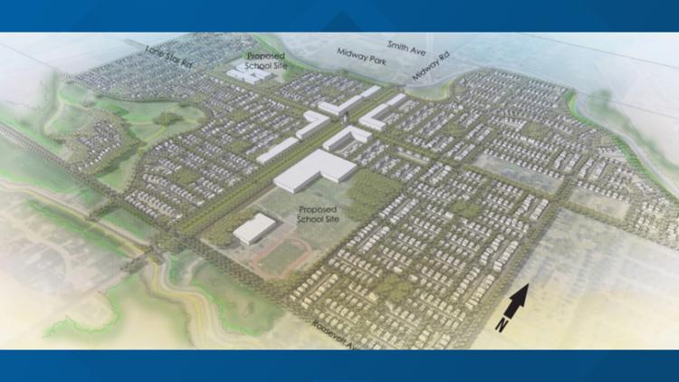
As Nampa looks at its undeveloped southwest, the goal is to make the area a true extension of the city, rather than becoming a collection of subdivisions.
The defined boundaries of southwest Nampa extend north to Karcher Road and south to Lake Lowell Avenue.
The western perimeter parallels the Deer Flat National Wildlife Preserve and the eastern boundary ends before Middleton Road.
Discussions with property owners showed that the majority were interested in developing their land, if not now, at least in the future. This encompasses a total of over 800 acres of land that southwest owners were willing to develop.
“There is very little area that just wants to remain agricultural land,” Critchfield said.
Critchfield said the city intends to preserve farm land by focusing on density.
City planners have conceptualized a grid system where the center is defined by mixed-use and high-density zoning. High-density housing typically includes apartments and duplexes.
For Nampa, the mixed-use zone could include residential spaces that are above businesses, labelled as the Midway/Lone Star District.
Around the central high-density zone will be medium-density zoning, which is then surrounded by low-density zoning, creating a sort of gradient.
This will keep low-density housing on the outskirts, and keep the wildlife refuge and Lake Lowell away from busier developments.
“The vision for development (in southwest Nampa) is organized around a central Midway/Lone Star District that will serve as a mixed-use hub,” the plan states.
CONSIDERING PRIORITIES
The city collected the opinions of area landowners through questionnaires and discussions about proposed land development. The survey was concluded in May and the city also held public meetings.
Out of 175 that filled out questionnaires, 75% did not want further population growth, but were otherwise supportive of the plan.
If growth were to inevitably occur, community members voiced traffic safety and accessible pathways as priorities.
The Specific Area Plan described current walking and biking infrastructure in the area as “very limited” with rural roadways that do not have sidewalks.
Connected transportation has been considered with existing roads and plans to add pathways that lead to Lake Lowell.
Critchfield also listed solutions like paths that are padded with landscaping between pedestrians and the road. Proposed north-to-south and east-to-west paths would intersect in the central mixed-use zone.
“Neighborhood bike routes will increase connectivity for people traveling from home by bike to meet daily needs,” the plan states. “Links to key destinations such as schools, parks, open spaces, and the retail corridor are emphasized.”
Southwest Nampa includes Huckleberry Dog Park and Midway Park with its sports facilities and playground.
While the city’s Specific Area Plan states that the Nampa School District has plans to build an elementary school and a high school in the area, NSD Media Relations Specialist Matt Sizemore clarified that there are no specific plans.
“Though the district does own the land that is referenced … there are currently no plans to bond for new schools to be built in the Nampa School District,” Sizemore wrote in an email.
The district has owned two plots of land in southwest Nampa for approximately 15 years.
The NSD ran a bond in early 2023 with a proposal to build a new Nampa High School and a new Centennial Elementary School. According to the district’s website, the current buildings were built in 1955 and 1975, respectively.
The bond, which needed a 66.7% supermajority vote in favor to pass, garnered 60.1% support.
“When the bond didn’t pass, those plans were obviously scrapped, and there’s been no talks or plans around building new schools,” Sizemore wrote.
More information on the development of southwest Nampa can be found on the city’s SW Nampa Specific Area Plan page on the city’s website. Questions about the plan can be directed to the Planning & Zoning Department’s Long Range Planning Team at PZLR@cityofnampa.us.
This article originally appeared in the Idaho Press, read more on IdahoPress.com.