The start of meteorological winter, which will begin on Dec. 1, is more than a month away, but some parts of the country have already had a taste of the season that's to come with early bouts of snow setting long-standing autumn records. And one phenomenon that's occurring thousands of miles away, that is associated with sea-surface temperature changes in the middle of the Pacific Ocean, is providing AccuWeather forecasters with insights into what weather patterns will unfold across North America during the upcoming winter months.
When determining the long-range weather forecast, meteorologists analyze large-scale climate patterns that can affect the weather around the world for extended periods of time. The process is significantly different than that of crafting a short-term forecast, such as examining a hurricane and predicting where it will head over the course of seven days.
One of the most well-known climate phenomena is El Niño, and its counterpart is a phenomenon that is happening right now: La Niña. Both of these have origins in the Pacific Ocean and can influence the weather thousands of miles away -- and in fact, around the globe.
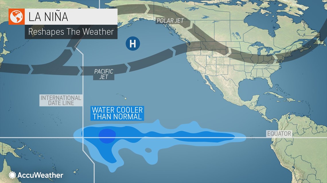
"La Niña is basically the cooling of the surface water in the central and/or eastern Equatorial Pacific and the warming of surface water in the western Equatorial Pacific," AccuWeather Long-Range Expert Paul Pastelok said. "This causes changes in the surface and upper wind patterns that drive air masses across the globe."
During a La Niña pattern, the ocean and atmosphere work together to generate certain weather patterns around the world, he added. However, not all La Niñas are created equal, and thus, there can be variations in weather patterns that develop.


NOAA announced that La Niña was officially underway back in August and issued a La Niña advisory as it will continue to influence the weather pattern in the coming months.
"La Niña is likely to continue through the Northern Hemisphere winter 2020-21 (~85% chance) and into spring 2021 (~60% chance during February-April)," meteorologists at NOAA's Climate Prediction Center said earlier this month.
This winter will be the first Northern Hemisphere winter to be influenced by a La Niña since the 2017-2018 season.
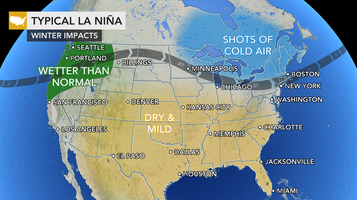
There are many different variables to consider when making long-range forecasts, but in general, a winter during which there is a La Niña tends to have certain characteristics across the United States. Read on to see the breakdown across different regions of the nation:
Pacific Northwest: Storms moving in from the Pacific Ocean tend to focus on this region of the West Coast and occasionally dip down into Northern California. This also translates to bountiful snowfall over the mountains.
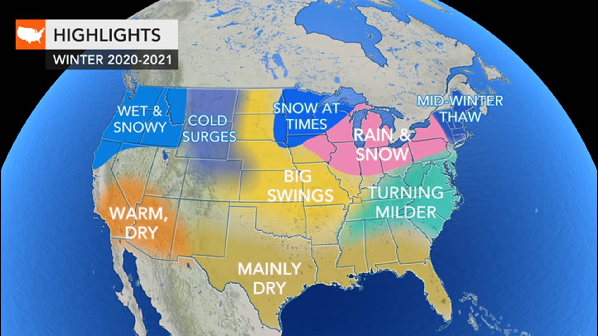
This year, however, storms that slam into the Pacific Northwest may also deliver more snow to the mountains of Wyoming, northern Utah and the northern Colorado Rockies than what is measured in a typical La Niña year, Pastelok said.
Southwest and southern Plains: Prolonged dry spells are usually paired with above-normal temperatures. Dryness across these regions over the winter can lead to the development or worsening of drought conditions during the hot season if La Niña conditions hold -- which could spell more bad news for fire-ravaged parts of the Southwest.


Midwest and interior Southeast: Cold and snowy conditions tend to focus on areas around the Great Lakes and can occasionally plunge southward into the interior Southeast and along to the west of the Appalachian Mountains. "This area can be shifty depending whether the sea-surface-temperature anomalies across the central Equatorial Pacific are cooler than eastern areas," Pastelok added.
Northeast: Warm air can be drawn up the East Coast into the mid-Atlantic and aim for areas east of the Appalachian Mountains, leading to below-normal snowfall along much of the Interstate-95 corridor. In contrast, snowfalls tend to occur over a zone stretching across the Tennessee Valley, Ohio Valley and interior Northeast.
This is generally what is expected to unfold across the U.S. this winter, but there will be some differences, according to AccuWeather's team of long-range forecasters, which is led by Pastelok.
One of the most notable differences is the storm track across the Midwest. There could be a "bigger dip in the storm track over the Midwest, Ohio Valley and Great Lakes at some point in the winter season, probably mid- to late-season, and can lead to a couple of bigger snow events for the Midwest and western Great Lakes," Pastelok explained.
Across the other side of the nation, there may be some echoes from last winter in major cities of the East Coast. A snow drought brought unusually low seasonal totals to the region last winter, and the pattern could bring a pause in wintry conditions around the middle of the season this year.
"Another overall mild winter is possible for much of the eastern U.S.," Pastelok said, referring to how temperatures will compare to the 30-year averages in many places. However, conditions won't be mild throughout the season, and instead it will be bookended with a cold and wintry start and the potential for coastal storms to bring snow events in the latter part of the season. Overall, near-normal snowfall is predicted across much of New England.
Before winter even arrives, La Niña can also play a major factor in the rest of the Atlantic hurricane season. The phenomenon is one of the reasons the current season has been hyperactive, according to meteorologists.
"What happens in a La Niña is the [wind] shear is more fragmented, less frequent, and so you have much more opportunity for tropical development across the basin," AccuWeather Hurricane Expert Dan Kottlowski said.
As of Oct. 21, there have been 26 named tropical systems in the Atlantic basin, which is just two storms shy of tying the all-time record number of tropical storms set back in 2005, and hurricane season doesn't officially end until Nov. 30.
Meanwhile, the eastern Pacific experiences fewer-than-normal tropical systems when there is a La Niña in effect.
Looking into next spring, if La Niña continues well into 2021, it could contribute to an uptick of severe thunderstorms and tornadoes across the central U.S. from March through May.
"La Niña can produce strong and more frequent severe weather events from the Plains on east in the spring and early summer," Pastelok said.
However, AccuWeather meteorologists are not yet confident as to whether the water over the central and eastern Equatorial Pacific will remain below normal through the spring or if the water temperatures will gradually rise during the first part of 2021, spelling an end to the current La Niña phenomenon.
The far-reaching effects of La Niña extend well beyond North America and the Atlantic Ocean, and the influence can be felt across nearly every continent.
"The western Pacific Islands, Indonesia and northern Australia can be wetter during a La Niña winter," Pastelok explained. It can also cause weather conditions to be cooler-than-normal in Japan and cool and wet weather to frequent southern Africa and Madagascar.

