
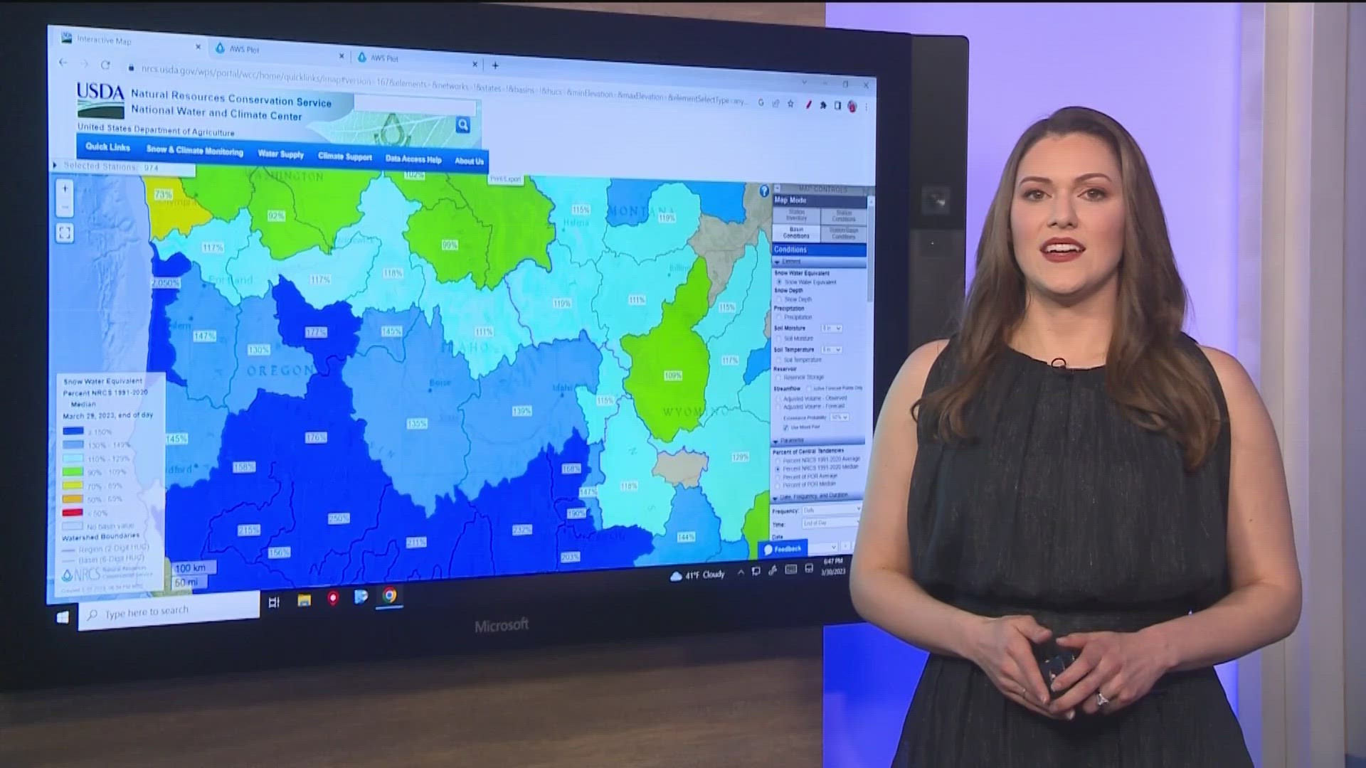
BOISE, Idaho — This month's rain and snow continues to stack up. Boise will likely see its fifth-snowiest March on record. Meanwhile, many mountain locations across southern Idaho are above 100% of the snow water equivalent for this time of year.
So, with all this snow and the corresponding water, is there a chance of flooding this year?
Like with many situations, one way to try and figure out what's going to happen is by looking at similar past situations. So, one way we can analyze how much water we may see when the snow melts is to look at SNOTEL data. SNOTEL data only goes back to 1981, so it's not a full look back in history, but it does offer some insight.

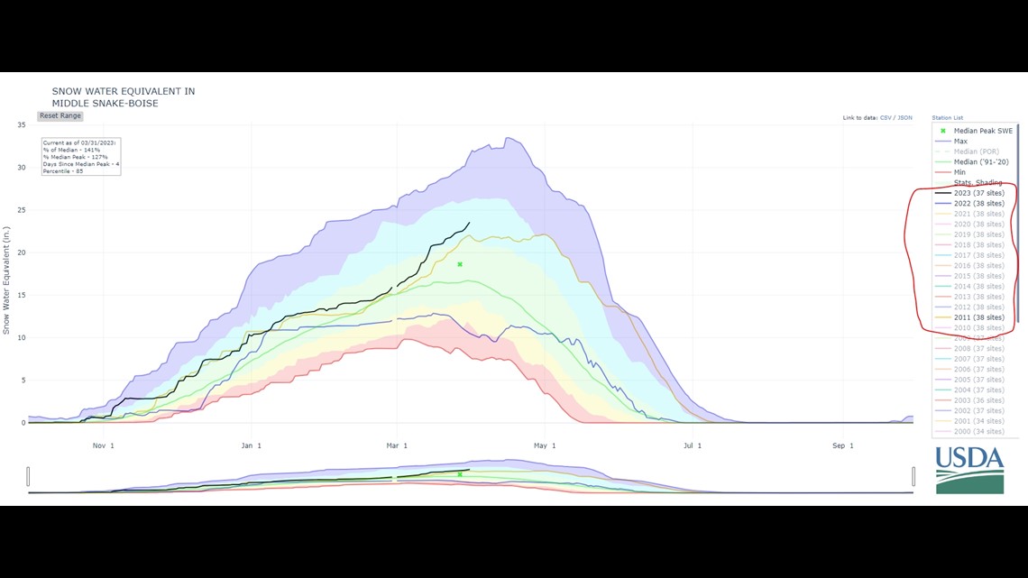
The graph above shows the Middle Snake Basin as a whole, which includes the western part of Idaho and eastern parts of Oregon. The purple line at the top shows the maximum snow we have seen, and the red line at the bottom shows the minimum snow we have seen. The black line shows 2023 so far. The green line in the middle shows the median snow amount.
If we look at the basin and how we have accumulated that snow over time, you will notice 2022 and 2023 parallel each other from January to March. We saw more precipitation this year, but it was a similar trend for the first few months of the year. March is where the trends start to diverge. In March 2023, the black line goes up, and in March 2022 the trend flatlines and then decreases.
This pattern is really similar at several SNOTEL sites too.

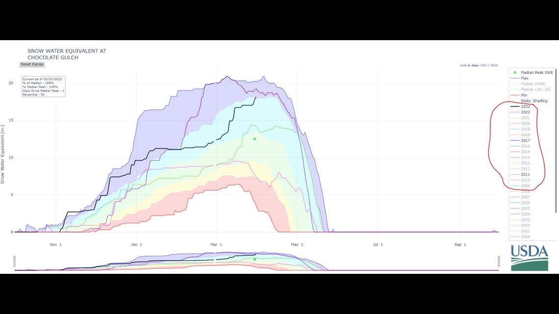
If we look at the Chocolate Gulch site (pictured above), which is the closest site to Sun Valley, you can find that similar pattern for the start of 2022 and 2023. We see a parallel path, rather dry conditions from January to March, and then again March is where we see a massive difference.
So, we know the runoff this year is not going to be similar to last year, because we are seeing huge differences in late in the season. After doing some comparisons across about 10 different SNOTEL sites, 2011 looks to be a similar trend to what we have been seeing this year. However, for some sites, 2017 matches up pretty well, too.
Mike Meyers is the Watermaster for the Boise Metropolitan Area, and he explained some of the records he has about what runoff looked like in 2011.
"In 2011, we started flood control operations March 21. I don't believe it really warmed up until April," Meyers said. "They did start flood control early, knowing there was a lot of snow up in the mountains. Then, it did not end until July 14."
Meyers agreed with the assessment that our snowpack is somewhere between 2011 and 2017 amounts.
"In 2011, there was 2.4 million acre-feet of runoff. In 2017, there was 3 million acre-feet of runoff. So, we could see very similar numbers," Meyers said. "The one thing I've noticed this year is, in the mountains, the ground was really dry before it snowed, and then it froze. So, the soil moistures in the hills, it's pretty dry under that snowpack, so we'll lose a little bit of that. But I still think, you know, if history tells us anything, we're right around that 2 million acre-feet runoff."
In 2011, parts of eastern Idaho were under state disaster declarations because of flooding. In May of that year, the Snake River was running high and threatened some neighborhoods near Heyburn. The Boise River was running high too.
"I did talk to some Ada County folks today, there was some localized flooding along the greenbelt that year," Meyers said. "Nobody really remembers anything too extreme, but there was localized flooding that year."
In 2022, the Bureau of Reclamation said they went into flood control operations for one day. This year, they will be releasing extra water for at least five days, with another possible increase on April 10.
Meyers adds that flood control operations typically mean reservoirs are full. So, he expects a full irrigation season this year.
While colder temperatures are a lot less pleasant than our typical spring-time temps, they will help the snow melt slowly – and hopefully avoid significant flooding.
Watch more Local News:
See the latest news from around the Treasure Valley and the Gem State in our YouTube playlist: