BOISE, Idaho — A potent storm system off the Pacific Northwest coast is slowly weakening after it wreaked havoc across western Washington overnight Tuesday into Wednesday. That system is the culprit behind the strong winds that have been howling across eastern Oregon and SW Idaho today. The system has also connected to an atmospheric
river in the central Pacific, which is channeling deep moisture across northern California and on into our neck of the woods. This atmospheric set-up has triggered First Alert Weather conditions for Wednesday and Thursday as wind, heavy rain and very high-elevation snow will impact travel and outdoor plans across the region in the coming days.
While light mountain snow and isolated rain showers did pop up Wednesday, the biggest impact were the howling winds, with gusts were strong enough at one point to briefly shut down I-84 in eastern Oregon (it's back open as of 1:30pm Wednesday). The wind will die down a bit overnight, but we will likely be contending with breezy to windy conditions for the next several days as the storm system continues to spin its wheels off to the west through Saturday.
A Winter Weather Advisory for the West Central and Boise Mountains is set to expire at 5am Thursday as snow levels start to rise due to mild southwesterly flow. That means precipitation will turn to a cold rain below 7,500' as temperatures warm through Friday. This could be a significant precipitation event for the west central mountains in particular, as some forecast models are predicting 2-3" of liquid equivalent through Saturday night, most of which will likely as fall as rain due to temps into the 40s in places like McCall by Friday. The rain on top of earlier snowfall may make for messy mountain travel in the coming days. Blowing snow will also be a visibility concern in the very high terrain, so drivers are urged to use caution if traveling in the high country this week.
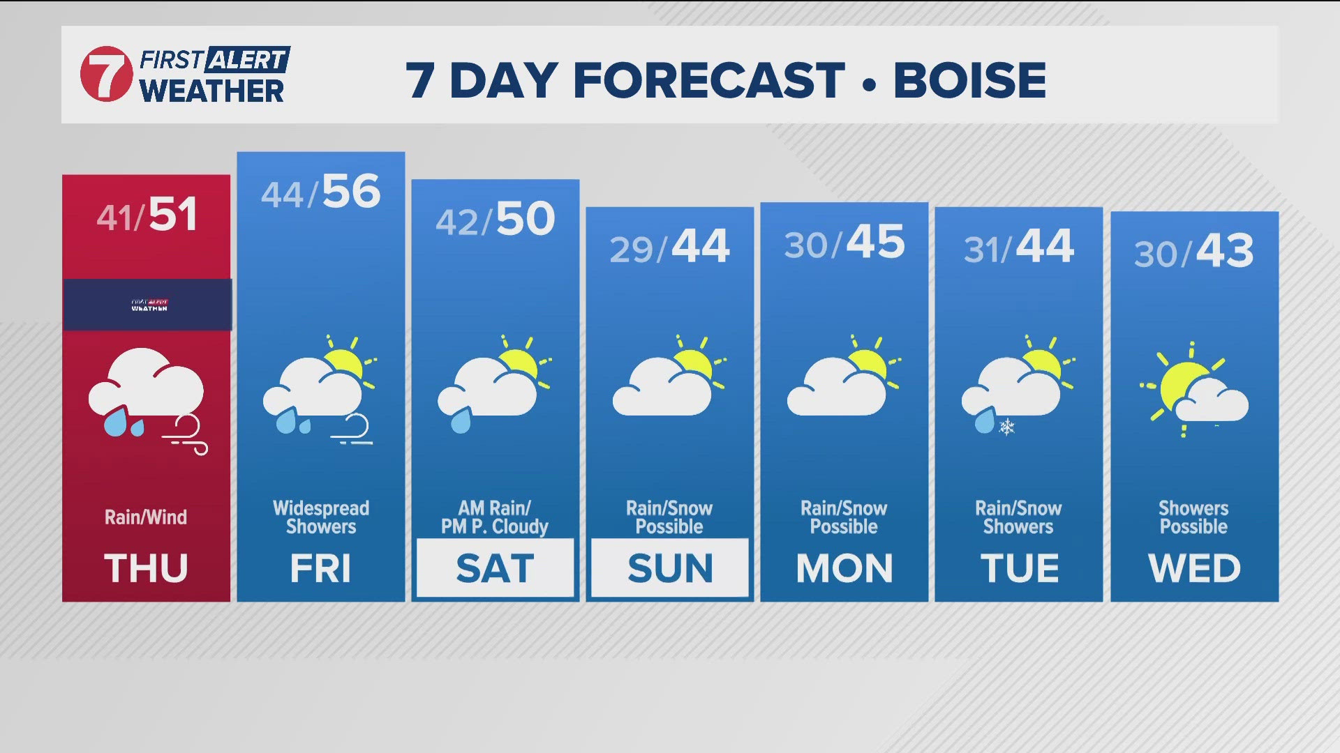
In the Treasure Valley, our cool and windy Wednesday leads to a soggy Thursday, as rain looks to fire up overnight and remain persistent throughout the day. Rain chances continue all the way through the weekend, with colder air moving on in Sunday as the trough finally starts making its way inland. This means snow showers are possible in the valleys Sunday and Monday morning, with heavy snow continuing to accumulate above 7,000' through early next week. Up to 2 FEET of snow is possible across some of the highest mountain peaks of central Idaho, and heavy snow combined with gusty winds will make for dangerously low visibility and poor traction at times. There is a Winter Storm Warning in place for the central mountains including the Stanley Basin, the Sawtooth mountains, and the Sun Valley region from Wednesday through Friday for potentially dangerous travel.
Starting early next week, a series of weak system are expected to roll across the area, with additional chances for precipitation possibly hanging on into the Thanksgiving holiday.
Post your photos using Near Me in the KTVB app and you can also share them in our Idaho Weather Watchers Facebook group.
GET WEATHER ALERTS: How to customize and navigate the KTVB app
KTVB Weather Team
- Chief Meteorologist Rachel Garceau joined KTVB’s First Alert Weather team in early 2023 and was promoted to Chief Meteorologist in September of 2024. While Rachel started her news career behind the scenes as a producer, she eventually moved in front of the camera as a news anchor and fill-in weather anchor. After spending some time on the green screen, Rachel realized she had a passion for the “why” behind the weather, and especially for the challenges presented by forecasting Idaho’s four distinct seasons. You can catch Rachel's forecasts Sunday through Thursday evenings at 5, 6 and 10pm.
- Meteorologist Sophia Bliss has been a part of the KTVB team since December of 2019. She started producing for the Wake Up Idaho team and continues to work as a producer. Additionally, Sophia is a meteorologist. She writes special weather stories and forecasts as a member of the First Alert Weather team. She loves the science of weather and enjoys the opportunity to explain how “magic” of the science works.
- Weather Anchor Hector Mendoza joined KTVB in June of 2023 as a Multi Skilled Journalist and became a member of the First Alert Weather team shortly thereafter, in July of 2023. Hector started off as the weather anchor for KTVB's Saturday Morning News but rang in 2024 by also taking over weather duties for the News at Noon. Whether planning for the week ahead or just wondering what's in store for the weekend, Hector is excited to help keep Idahoans informed about the conditions that matter most to them. You can catch him on Saturday mornings from 8-10am and on the News at Noon Tuesday through Friday.
Watch more weather:
See the latest weather forecasts and news in our YouTube playlist:

