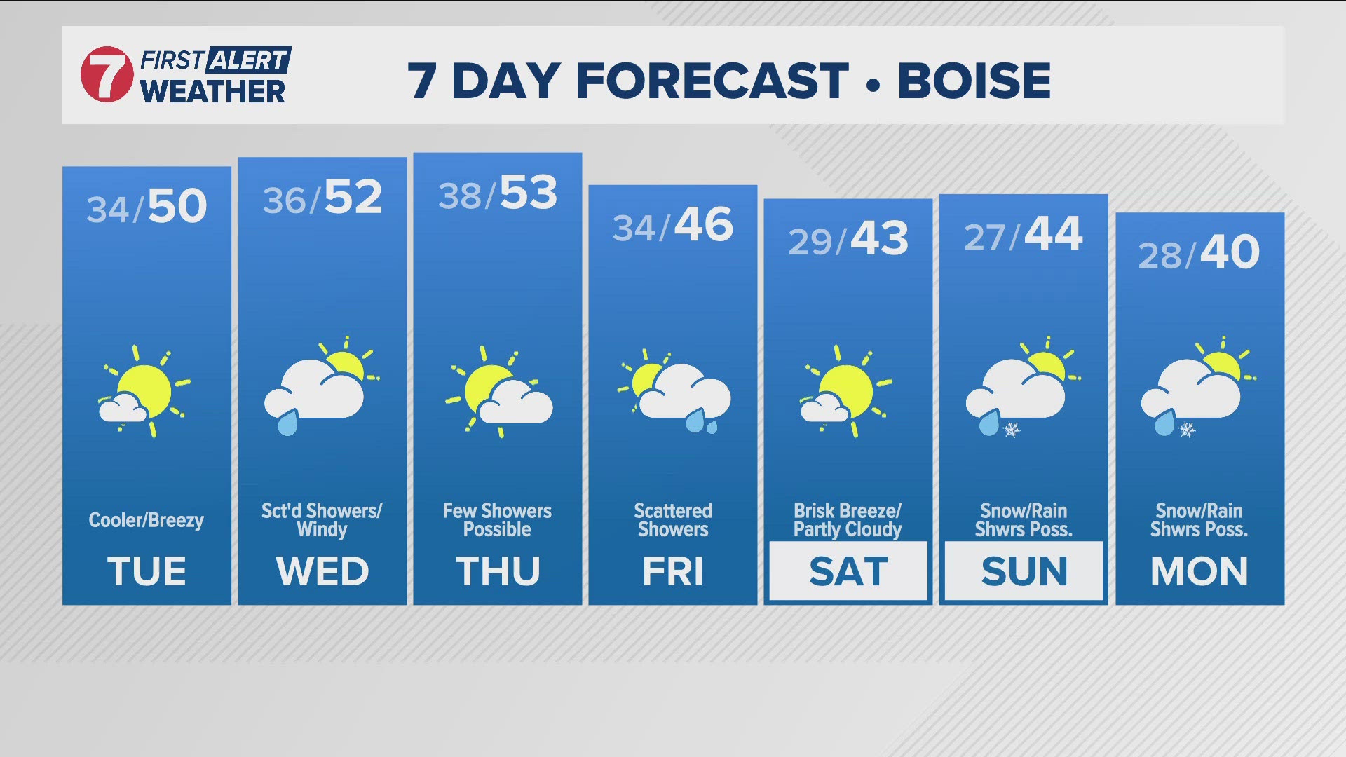
BOISE, Idaho — After a wet and showery end to Veterans Day yesterday, Tuesday will be mostly dry, mostly clear, and cooler, with a brisk northwest wind gusting up to 30mph at times, so don't let the sunshine deceive you: grab a coat on your way out the door! Much strong winds in the Twin Falls and Jerome area, strong enough for a Wind Advisory in the western Magic Valley. The advisory is in effect from 9am to 3pm as west winds will be around 30mph with gusts 40 to 50mph expected.
Although we have drier and sunnier conditions today, keep the umbrella nearby as valley rain and mountain snow will return Wednesday, with snow levels between 4,500 and 5,500 feet. The West Central Mountains could see 4+ inches of snow by Wednesday night, and strong southerly winds are expected.
Looking ahead, scattered showers will continue Thursday, with a slight drying trend later in the day. Another cold front arrives Friday, dropping snow levels to around 4,000 feet and bringing cooler temps and gusty winds. Snow chances will decrease on Saturday, though some snow could linger in higher elevations. Temperatures will remain below normal, with highs only in the mid-40s in Boise over the weekend, and morning lows down into the 20s.
More precipitation may arrive late Sunday into Monday as yet another Pacific storm system takes aim at the intermountain west, with snow levels potentially down to valley floors by then. Overall, mountain locations above 5,000' could see 10-12" of snow over the next 7 days, with a dusting possible in the Treasure and Magic Valleys by early next week as unsettled conditions continue long-term.
Post your photos using Near Me in the KTVB app and you can also share them in our Idaho Weather Watchers Facebook group.
GET WEATHER ALERTS: How to customize and navigate the KTVB app
KTVB Weather Team
- Chief Meteorologist Rachel Garceau joined KTVB’s First Alert Weather team in early 2023 and was promoted to Chief Meteorologist in September of 2024. While Rachel started her news career behind the scenes as a producer, she eventually moved in front of the camera as a news anchor and fill-in weather anchor. After spending some time on the green screen, Rachel realized she had a passion for the “why” behind the weather, and especially for the challenges presented by forecasting Idaho’s four distinct seasons. You can catch Rachel's forecasts Sunday through Thursday evenings at 5, 6 and 10pm.
- Meteorologist Sophia Bliss has been a part of the KTVB team since December of 2019. She started producing for the Wake Up Idaho team and continues to work as a producer. Additionally, Sophia is a meteorologist. She writes special weather stories and forecasts as a member of the First Alert Weather team. She loves the science of weather and enjoys the opportunity to explain how “magic” of the science works.
- Weather Anchor Hector Mendoza joined KTVB in June of 2023 as a Multi Skilled Journalist and became a member of the First Alert Weather team shortly thereafter, in July of 2023. Hector started off as the weather anchor for KTVB's Saturday Morning News but rang in 2024 by also taking over weather duties for the News at Noon. Whether planning for the week ahead or just wondering what's in store for the weekend, Hector is excited to help keep Idahoans informed about the conditions that matter most to them. You can catch him on Saturday mornings from 8-10am and on the News at Noon Tuesday through Friday.
Watch more weather:
See the latest weather forecasts and news in our YouTube playlist:

