BOISE, Idaho — Widespread precipitation continued Saturday afternoon with isolated thunderstorms and gusty winds in the region. Rain is likely to continue throughout the night in the valleys with patchy fog expected to roll in after midnight. Lows will be colder for the night from the mid 20s to low 30s. Winds are somewhat light up to 10mph and gusts up to 25mph. Mountain areas have 90% chance of snow for the night with patchy fog expected. Higher elevations may get up to 4 inches of snow accumulation overnight with showers continuing through Sunday morning.
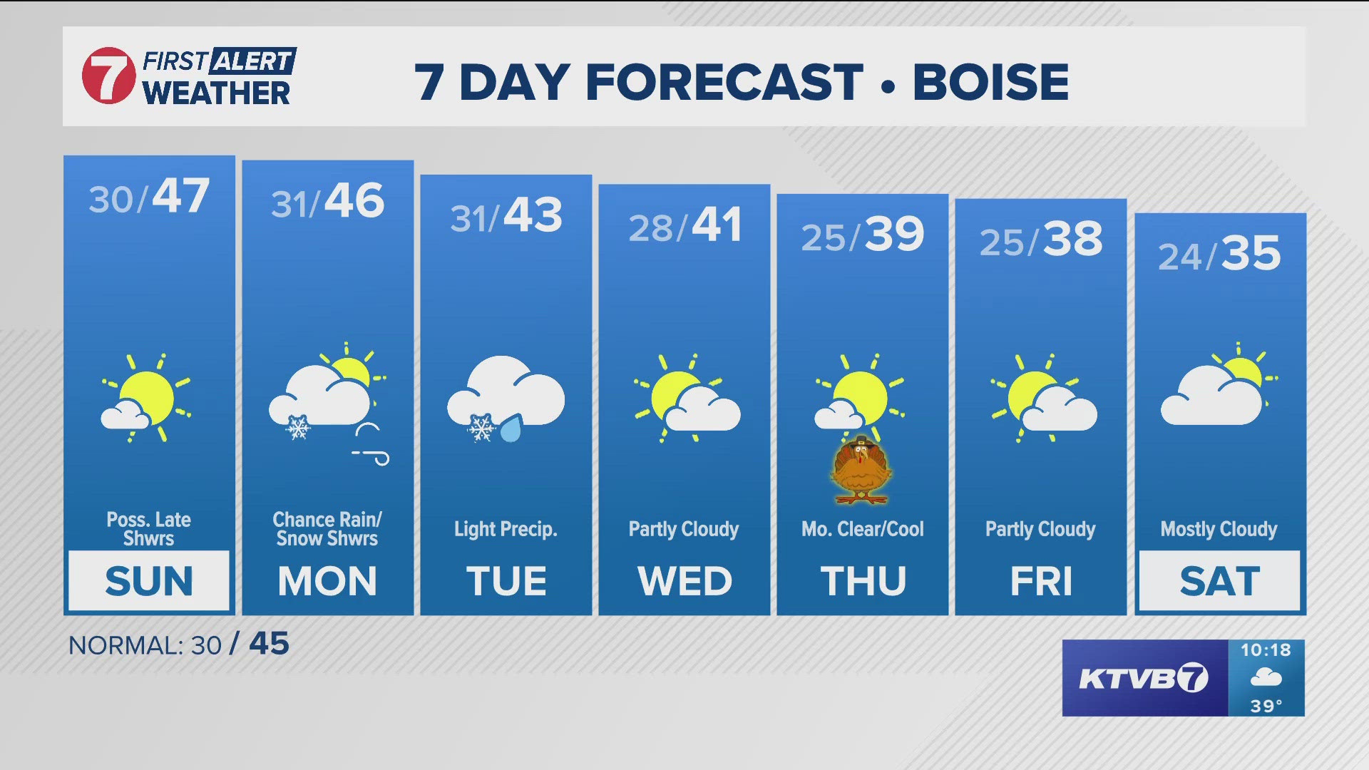
Most regions can expect patchy fog Sunday morning. Sunday looks to be sunny and clear for most of the day with a chance of rain coming late Sunday night closer to midnight. The mountains still have a slight chance of snow in the evening.
The Treasure Valley and the Magic Valley have a chance of snow Monday morning. The mountains will likely have snow Monday morning but little accumulation is expected. Monday looks to have breezier conditions with winds up to 20mph and gusts up to 30mph in some areas.
Starting early next week, a series of weak systems are expected to roll across the area, keeping light precipitation around through Tuesday. Tuesday calls for 60-80% chance of precipitation in the mountains with snow levels dropping to 3,000-4,000 feet. As of now, totals look to only be 1-2 inches.
Wednesday starts an extended period of dry weather for the rest of the week. Thanksgiving Day is looking to be cold with the highs in the upper 30s, but fairly dry with light winds. There is a slight cooling trend in temperatures from the middle to end of the week. Temperatures will be slightly lower than normal.
Some models are hinting at the possibility of a low level inversion with stagnant air conditions toward the end of the week.
Post your photos using Near Me in the KTVB app and you can also share them in our Idaho Weather Watchers Facebook group.
GET WEATHER ALERTS: How to customize and navigate the KTVB app
KTVB Weather Team
- Chief Meteorologist Rachel Garceau joined KTVB’s First Alert Weather team in early 2023 and was promoted to Chief Meteorologist in September of 2024. While Rachel started her news career behind the scenes as a producer, she eventually moved in front of the camera as a news anchor and fill-in weather anchor. After spending some time on the green screen, Rachel realized she had a passion for the “why” behind the weather, and especially for the challenges presented by forecasting Idaho’s four distinct seasons. You can catch Rachel's forecasts Sunday through Thursday evenings at 5, 6 and 10pm.
- Meteorologist Sophia Bliss has been a part of the KTVB team since December of 2019. She started producing for the Wake Up Idaho team and continues to work as a producer. Additionally, Sophia is a meteorologist. She writes special weather stories and forecasts as a member of the First Alert Weather team. She loves the science of weather and enjoys the opportunity to explain how “magic” of the science works.
- Weather Anchor Hector Mendoza joined KTVB in June of 2023 as a Multi Skilled Journalist and became a member of the First Alert Weather team shortly thereafter, in July of 2023. Hector started off as the weather anchor for KTVB's Saturday Morning News but rang in 2024 by also taking over weather duties for the News at Noon. Whether planning for the week ahead or just wondering what's in store for the weekend, Hector is excited to help keep Idahoans informed about the conditions that matter most to them. You can catch him on Saturday mornings from 8-10 a.m. and on the News at Noon Tuesday through Friday.
Watch more weather:
See the latest weather forecasts and news in our YouTube playlist:

