BOISE, Idaho — The atmospheric river will continue to impact the region today. So, First Alert Weather conditions continue Thursday as wind, rain and high-elevation snow will impact travel and outdoor plans across the region in the coming days. In the Treasure Valley, our cool and windy Wednesday leads to a soggy Thursday, as rain fired up overnight and continued on and off through the afternoon and picked up this evening.
Ski areas stacked up about 6-8 inches of snow, but temperatures warmed into the evening and snow started to fall as rain in parts of the west central and Boise mountains, leading to some melting.
Warmer air will continue to work its way in overnight prompting snow levels will continue to rising, reaching 8000+ feet near the Nevada border and 5500-6000 feet from Baker City to McCall.
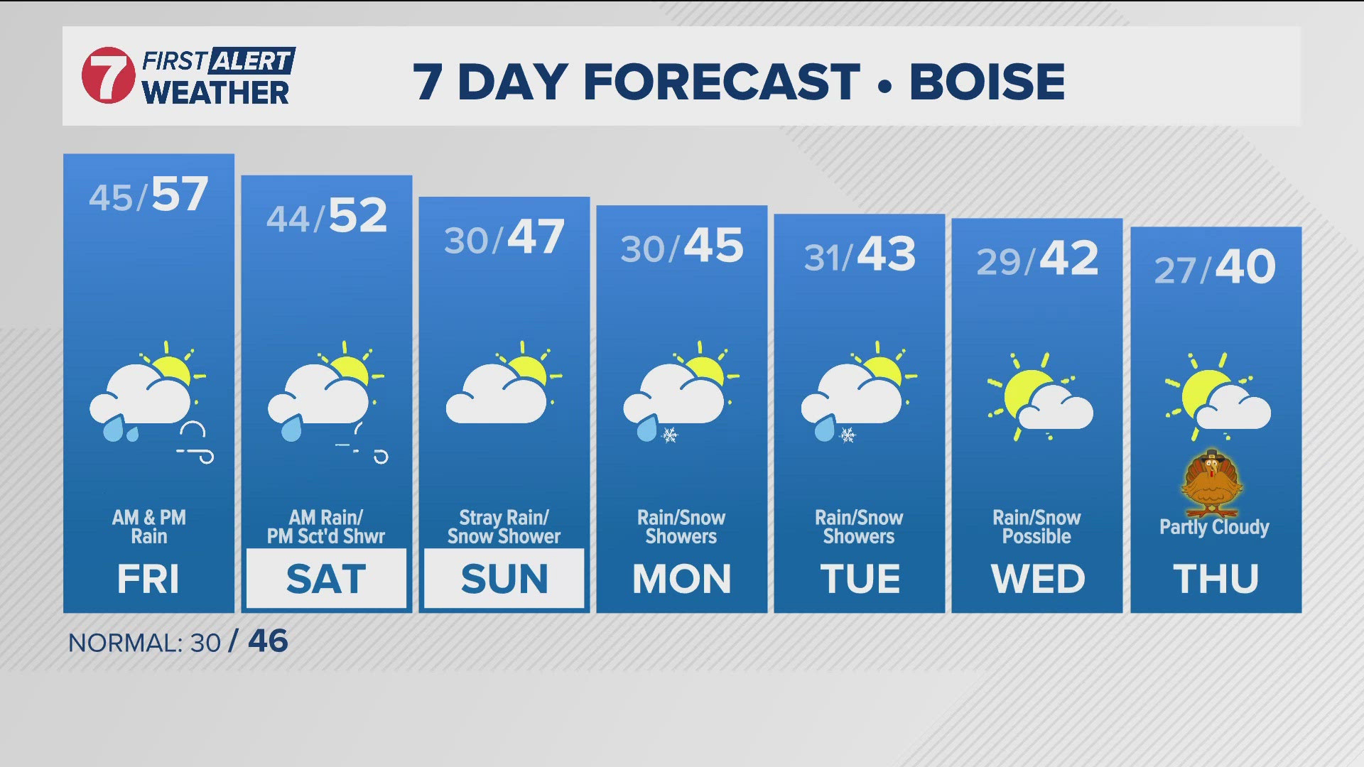
Rain chances continue all the way through Saturday, but precipitation is expected to briefly decrease through the daytime hours of Friday. This warming trend will bring highs into the mid to upper 50s across lower elevations, with a few locations possibly reaching into the lower 60s.
A cold front is still on track to move through Friday night, accompanied by widespread precipitation. Snow levels lower to around 5000 feet behind the front by Saturday morning. The heaviest snowfall is expected to be limited to elevations above 6500 feet where additional snowfall totals will likely exceeding a foot.
Colder air moves on in Sunday as the trough finally starts making its way inland. This means snow showers are possible in the valleys Sunday and Monday morning, with heavy snow continuing to accumulate above 7,000' through early next week. Up to 2 FEET of snow is possible across some of the highest mountain peaks of central Idaho, and heavy snow combined with gusty winds will make for dangerously low visibility and poor traction at times. There is a Winter Storm Warning in place for the central mountains including the Stanley Basin, the Sawtooth mountains, and the Sun Valley region through Friday morning for potentially dangerous travel.
Starting early next week, a series of weak system are expected to roll across the area, with additional chances for precipitation possibly hanging on into the Thanksgiving holiday.
Post your photos using Near Me in the KTVB app and you can also share them in our Idaho Weather Watchers Facebook group.
GET WEATHER ALERTS: How to customize and navigate the KTVB app
KTVB Weather Team
- Chief Meteorologist Rachel Garceau joined KTVB’s First Alert Weather team in early 2023 and was promoted to Chief Meteorologist in September of 2024. While Rachel started her news career behind the scenes as a producer, she eventually moved in front of the camera as a news anchor and fill-in weather anchor. After spending some time on the green screen, Rachel realized she had a passion for the “why” behind the weather, and especially for the challenges presented by forecasting Idaho’s four distinct seasons. You can catch Rachel's forecasts Sunday through Thursday evenings at 5, 6 and 10pm.
- Meteorologist Sophia Bliss has been a part of the KTVB team since December of 2019. She started producing for the Wake Up Idaho team and continues to work as a producer. Additionally, Sophia is a meteorologist. She writes special weather stories and forecasts as a member of the First Alert Weather team. She loves the science of weather and enjoys the opportunity to explain how “magic” of the science works.
- Weather Anchor Hector Mendoza joined KTVB in June of 2023 as a Multi Skilled Journalist and became a member of the First Alert Weather team shortly thereafter, in July of 2023. Hector started off as the weather anchor for KTVB's Saturday Morning News but rang in 2024 by also taking over weather duties for the News at Noon. Whether planning for the week ahead or just wondering what's in store for the weekend, Hector is excited to help keep Idahoans informed about the conditions that matter most to them. You can catch him on Saturday mornings from 8-10am and on the News at Noon Tuesday through Friday.
Watch more weather:
See the latest weather forecasts and news in our YouTube playlist:

